
Pietro Miotti · 2026-11-10 · notable
48 AI agents scan public lidar — and flag an unregistered Maya site
In short
Pietro Miotti, who says he is not an archaeologist, had 48 AI agents review lidar images of about 1,200 km² of Maya-region jungle. They flagged a hilltop site with a plaza and an oval pyramid that Mexico's INAH says is not registered.
Pietro Miotti · 2026-11-10 · 2 sources checked
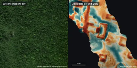
A non-archaeologist used 48 AI agents on public lidar data and found a Maya site missing from Mexico's register in under 72 hours.
What is it?
Pietro Miotti's post 'My AI Agents Found an Unmapped Maya Site' describes a hilltop site in Mexico with a levelled plaza, an oval pyramid at least 8–12 m tall, a raised courtyard and a hollow that may be a reservoir. Mexico's National Institute of Anthropology and History (INAH) replied that no registered archaeological site exists at the reported location.
How does it work?
The lidar strips were turned into images, and 48 agents went through them one by one with a written guide, looking for pyramids, platforms and plazas while ignoring natural hills, sinkholes and roads. No special model or classifier was used. When an agent pointed out a large village that did not seem to be registered, the author checked the raw point cloud and sent INAH a Spanish report with the coordinates in a confidential annex.
Why does it matter?
The search shows that off-the-shelf agents can do a first pass over large public remote-sensing datasets, from idea to an official reply in less than 72 hours. It is still only a lead: no archaeologist has checked the site in the field, and a field check needs INAH approval.
Who is it for?
people building multi-agent workflows, remote-sensing and archaeology researchers